New Project Forecasts Future of Puget Sound
Through a $4.8M effort, funded in part by the Paul G. Allen Family Foundation, the Puget Sound Institute will integrate existing environmental models to provide a cohesive picture of the entire Sound ecosystem under future conditions of climate change and population growth.
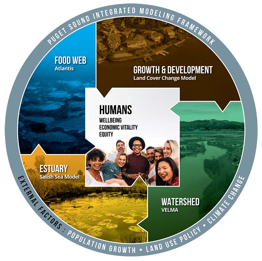
The Puget Sound Institute is launching a multi-year, $4.8M effort to enable better management actions through an integrated model of the Puget Sound ecosystem. The integrated model powerfully combines five smaller, more specific models of respective ecosystem components.
Most Comprehensive EndeavorAdvances in computer modeling mean PSIMF will be the most comprehensive effort so far to simulate environmental conditions connecting Puget Sound's land and water.
For Journalists |
Funded in part by the Paul G. Allen Family Foundation, the Puget Sound Integrated Modeling Framework (PSIMF) will pull together complementary modeling data from partners including UW’s Salish Sea Modeling Center, NOAA’s Northwest Fisheries Science Center (NFSC), the EPA’s Office of Research and Development (ORD), Long Live the Kings (LLTK), Pacific Northwest National Laboratory (PNNL), and the Commonwealth Scientific and Industrial Research Organization (CSIRO) of Australia.
“The Pacific Northwest is home to cutting-edge terrestrial, estuarine, and marine ecosystem models that each have their own use in supporting specific decisions and advancing understanding,” said Dr. Tessa Francis, lead ecosystem ecologist with UW Tacoma’s PSI and principal investigator on the project. “So far, we haven’t been able to link these models together to provide a unified platform with insights into the interconnected nature of our ecosystems.”
Francis likened the existing models to separate puzzle pieces that, when put together, will provide a cohesive picture of the entire ecosystem. Human populations and stressors originating from land development and climate change threaten freshwater, nearshore, and estuarine ecosystems. The connections between these areas are poorly understood, and these systems should not be studied one-by-one. Comprehensive data and analyses are needed to make informed conservation, restoration, and development decisions.

“This project links together land cover, freshwater, marine condition, and food-web models, which will greatly benefit the many organizations working to ensure the future of the Puget Sound ecosystem,” said Scott Redman, program director for Science and Evaluation at the Puget Sound Partnership. “We look forward to partners using the integrated model to inform their decisions about growth management, shoreline protection, pollution control, and species recovery.”
The foundational modeling data to be incorporated into the project include:
- VELMA ecohydrological watershed model developed by EPA-ORD
- Salish Sea Model from the Salish Sea Modeling Center and PNNL
- Atlantis ecosystem model, developed by CSIRO and implemented by LLTK and NOAA’s NWFSC
- High resolution land cover change model from PSI
- Qualitative socio-ecological model coordinated by NOAA’s NWFSC
Support of VELMA and the Salish Sea Model by EPA’s Puget Sound Geographic Program has enabled their individual development to this point, making them ready for use in a coupled framework. “The integration of these models will create new decision-making tools that positively impact the future of our region,” said Dr. Gabe Miller, Technology Director on behalf of the Paul G. Allen Family Foundation. “This project reflects the foundation’s long-standing commitment to the Pacific Northwest and leveraging data to solve environmental challenges.”
Once completed, the project’s many linked models will create a fuller picture of the Puget Sound ecosystem, clarifying the relationships between climate, human populations, and land use. This new tool will support regional planning and decision-making, allowing smarter resource management that benefits diverse residents from kelp and fish to orcas and humans.


